Mappowder


Church of Sts Peter & Paul  © Chris Rumbold 2002


Mappowder is a parish on the edge of the Blackmore Vale, comprising a village with a few stone built cottages and the church. It is 7 miles south-west from Sturminster Newton and 10 miles north-east from Dorchester. The name is said to derive from the Old English word 'mapluldor' meaning a maple tree, in 1066 it was referred to as 'Mapledre' in the Domesday Book.  The church dedicated to the Saints Peter & Paul is mainly of late 15th century construction with a tower built in 1868 in the same style as the original building.


In a recess is a small effigy of a 13th century knight, this is said to commemorate the death of a crusader whose heart was back for burial in his home parish. The registers date from 1653. A National School was built in the parish in 1870 for 50 children. The area of the parish is 1887 acres and the soil is chiefly clay and gravel with most of it laid to pasture. The population in 1861 was 238 and in 1891 was 195 persons.


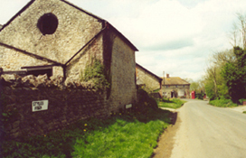
The main street with Styles Farm in the foreground, picture taken from near the Church. ©  Eileen Penfold


The Online Parish Clerk (OPC) for Mappowder is  Eileen Penfold

Resources are available for look-up by contacting me. Unless specified, all transcriptions and indexes used to answer queries have been made by me. The list below represents the main transcriptions I have, there may well be other smaller items not listed, so it is always worth contacting me.
I will be building resources over the coming months so don't forget to come back regularly for the latest additions.


Census 1841 & 1851
1861 & 1871
1881, 1891 & 1901 
1911 [Godfrey Symes]
Parish Registers Baptisms 1653-1812 [Kim Parker]
Marriages  1654-1925  [Eileen Penfold]
Burials 1653-1708 [Kim Parker] 1709-1962 [Eileen Penfold]
Bishops Transcripts Baptisms 1733-1750, 1813-1877
Postal & Street Directories I have copies from the 1895, 1907, 1923 and 1935 post office directories
Electoral Register I have a copy of the 1874 electoral register for the parish
Prisoners List of prisoners appearing before special commission at Dorchester January 1831
Lay Subsidy Roll Mappowder lay subsidy roll of 1332
Photographs Photographs of Mappowder school children dated 1920, 1921
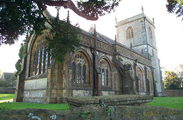
Monumental Inscriptions St Peter & St Paul
Maps
The 1891 Ordnance Survey maps of the parish can be seen at the old-maps site, just enter 'Mappowder' under place search.

For modern location maps visit:-  www.multimap.com or click on the thumbnail below for a 1920's map of the area. [157kb]

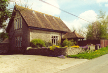
Mappowder Old School House, now a private dwelling. © Eileen Penfold


OPC PAGE

Visitors to Dorset OPC

Web Analytics

Privacy Policy

Copyright (c) 2024 Dorset OPC Project