Stourpaine
including Lazerton
|
|
Stourpaineincluding Lazerton |
|
|
Stourpaine is located in the shadow of Hodd Hill where the little river Ewerne meets the Stour, on the A350 to Shaftesbury, 3 miles North-North-West of Blandford. The village has its origins in the Saxon period and its name simply means "Estate on the Stour held by the Payn family", from the river that flows past and the surname of the 13th century lords of the manor here. According to the 2001 census the population was 608 residents, not a far cry from the 1867 total of 658, but happily in far different conditions. At that time the parish of Stourpaine, which included the hamlets of Ashe and Lazerton, lived from agriculture. Wages were lower here and, as a good deal of cottage property was either life-held or belonged to landlords who were not particular about their tenants, the village became a refuge for those turned away by other parishes. Nineteenth-century Stourpaine was in the grip of extreme poverty. The Vicar gave evidence to the Poor Law Commissioners for their report of 1867, describing cramped living conditions, with large families sharing one small room and children being kept out of school to grow food on the allotments or knit clothes for sale to bring in a few essential pennies for rent. There are now no farms based in Stourpaine, the nearest being Ash Farm. It is not known for sure whether there was a church
here in Saxon times, but being important enough to be entered into the
Domesday Book of 1085, where a gift of land to the church is recorded,
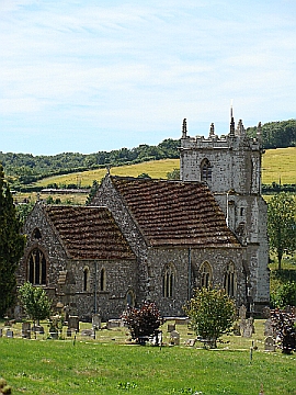
suggests that there may have been. Building on the site of the present
Church of the Holy Trinity began in 1190 and was completed in 1300. At
this time, there was also a chapel dedicated to St. Andrew at Lazerton,
but as it was only half a mile from Stourpaine and the vicarage was in
any case a poor one, the rectories were united in 1431. Like several
other villages in Dorset Lazerton had previously been decimated by the
Black Death in 1348. Later in the 15th century, the tower was demolished
and the present greensand tower was built. By the 18th century, the chancel
and nave were filled with large square pews all held by the families of
yeomen farmers, while there were benches for "the others". |
|
Sadly, by the mid-19th century, the church was in such
a poor state of repair that only the tower, together with its kneeling effigy
of John Straight, vicar here from 1650-69, could be saved. T. H. Wyatt
undertook the construction of a new chancel and nave, incorporating
elements of the original church where he could. Two perpendicular
windows survive in the north wall, but the ancient font "disappeared".
The elaborately carved oak pulpit was the work of four parishioners
and the vicar, who carved it in their spare time over a period of 3
years from 1911 to 1914 as a labour of love. More recently there has
been a major renovation of the Grade II listed Lychgate. |
|
|
|
|
| Census |
1841 Census [Andrew Wright] 1851 Census [Andrew Wright] 1861 Census [Andrew Wright] 1871 Census [Andrew Wright] 1881 Census [Andrew Wright] 1891 Census [Andrew Wright] 1901 Census [Andrew Wright] |
| Parish Registers |
Baptisms
1813-1856,
1856-1925 [Pam Sharkey] Marriages 1813-1849, 1837-1924 [Pam Sharkey] Burials 1813-1882 [Pam Sharkey] Extracts from the Registers in Hutchins [Kim Parker] Stourpaine Parish Registers (1631-1799) [Edward Alexander FRY] |
| Trade & Postal Directories | Extract from the 1865 & 1880 Directory [Lynda Small] |
| Other Records |
List of
Wills proved at Blandford [Lynda Small] Rectors of Stourpaine & Lazerton [Kim Parker] Roll of Honour {Kim Parker] Wills of Stourpaine Residents [Kim Parker] |
| Photographs | |
| Monumental Inscriptions | |
| Maps | |
|
View Larger Map |
|
| Records held at the Dorset History Centre [Ref PE-SPN] |
Registers Christenings 1631-1925. Marriages 1631-2012. Burials 1631-1881. Banns 1789-1940 |
| Registration District
(for the purpose of civil registration births, marriages & deaths) |
1 Jul 1837-30 Jun 1956: Blandford 1 Jul 1956-31 Mar 1974: Poole 1 Apr 1974-17 Oct 2005: North Dorset |
|
|
|
|
Visitors to Dorset OPC
Copyright (c) 2025 Dorset OPC Project