Dorset OPC

Talbot Village

Dorset OPC


SZ0694 : St Mark, Talbot Village by Michael FORD
St Mark, Talbot Village
© Copyright Michael FORD and licensed for reuse under this Creative Commons Licence.

Talbot Village is located on the boundary of Bournemouth and Poole, and was formerly part of the parish of Kinson, which itself was part of the parish of Great Canford until 1865. The original Talbot Village was built between 1850 and 1862 due to the generosity of two sisters, Georgina and Mary Anne Talbot. Georgina and Mary divided their year between Surrey and Hinton Wood House on the East Cliff of Bournemouth with their family and it was while living in Bournemouth that the sisters discovered the many poor who were suffering in the region after the Enclosure Act of 1822 had abolished their traditional right to free grazing, game and fuel on the surrounding common land.

Between them, they sought to employ the poor to clear the land to build cottages — these were completed between 1850 and 1862. The workers were allowed to stay in the cottages and slowly, Talbot Village began to develop. In all 5 farms, 7 almshouses, a school and 19 substantial cottages were built, a 6th farm was added by Lord Leven, Mary Anne's heir. The original cottages were built on an acre plot and each had a well, animal pens and fruit trees. The residents were charged a rent of between 4 and 5 shillings per week. 

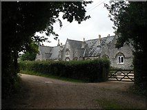
The school was built for the village in 1862 and held 68 children, it has since been extended over the years and in 1992 an extension 
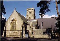
increased the school's capacity to 460 children. St Mark's Church was built and consecrated in 1870. St Saviour's Mission Church is a recent addition, dedicated in 1953.

Although most of the original farms have long since vanished, Highmoor Farm is still operational and White Farm served as stables until fairly recently. Much of the original village including the school, church, almshouses and cottages remain and are protected by a Conservation Order which is administered by the Talbot Village Trust — which was set up by the sisters.

[Text adapted from Wikipedia Talbot Village entry under a Creative Commons Attribution/Share-Alike License]

Highmoor is not noted on present day maps but is the area now known as Wallisdown. It encompassed the present day Canford Road and part of Kinson Road (northwards to what is now Columbia Road and Turbary Park Avenue). There are still many original Victorian cottage style houses in the area. The rest of it which lay on the other side of the present Wallisdown Road, has been built on and now has the Bournemouth University Campus and adjoining housing estate on it.


SZ0794 : Talbot Village: almshouses by Chris Downer
Talbot Village: almshouses
  © Copyright Chris Downer and licensed for reuse under this Creative Commons Licence.


The post of Online Parish Clerk (OPC) is currently vacant
If you would like to volunteer for the role, please contact the OPC Project Co-ordinator
Contributions of additional resource materials for the site are always welcome


Census 1841 Census
1851 Census
1861 Census (see Kinson)
1871 Census
1891 Census
1901 Census
Parish Registers Baptisms 1870-1906 [Vanessa Marshall]
Marriages 1905-1919 [Vanessa Marshall]
Burials 1870-1903 [Vanessa Marshall]
Trade & Postal Directories  
Other Records  
Photographs  
Monumental Inscriptions Talbot Village War Memorial Roll of Honour [External]
Maps  
Records held at the Dorset History Centre
[Formerly part of Kinson]
 
Registers
Christenings 1870-1991, 1994-1998 . Marriages 1905-1998. Burials 1870-1993.


OPC PAGE

Visitors to Dorset OPC

Web Analytics

Privacy Policy

Copyright (c) 2024 Dorset OPC Project