South Perrott
|
South Perrott |
|
|
|
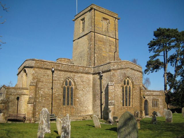
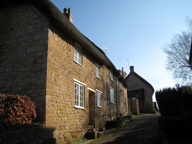
Running along either side of the A346, South Perrott is situated in the north-west corner of Dorset, near the Somerset border, at the foot of the hill leading to Winyard’s Gap. The nearest town in Dorset is Beaminster, and that in Somerset is Crewkerne. The village itself consists of quaint 17th and 18th century stone cottages on different levels. Standing like a citadel overlooking the village with the River Parrett nestling at its base, is the church of St Mary’s. Next to the church is the site of Mohun Castle, destroyed in the Monmouth Rebellion. About three quarters of a mile south of the village, the arched and traceried 15th century windows of Pickett Farm are visible from the road. It is here that Early Bronze Age and Roman artefacts have been found. South Perrott’s existence can be traced back to Norman times, as it is mentioned in the Domesday book. Hutchins recorded, “The same William holds Pedret of the Earl (of Chester). Alnod held it in the time of King Edward, and it was gelded for five hides. There is arable land to five ploughs. There are two ploughs in demesne, and three servi, and six villains, and fourteen bordars, with three ploughs. A mill there pays two shillings, and there are twelve acres of meadow, pasture fourteen quarentens long and five broad. It was worth a hundred shillings, now six pounds. Alnod bought this manor of Bishop Alwold for his life only, the agreement being that after his death it should be restored to the church.” |
|
The manor from then until the latter part of the 19th c. passed through many hands. The Maubanks family held it in the 14th c., then in the next century it passed first to the Carent family and later to the Horsey family of Clifton Maubank, and on to the Albini or D’Albeniaco family who assumed the name of Aubigny or D’Aubeney during the reign of Edward II, after which it became dispersed as Sir John Horsey’s daughters married into various families, including the Arnolds and the Mohuns. During the 18th c., the Earl of Radnor and the Phelippses of Montacute were among the owners. In the 19th c. the major landowners were Captain Draper, W. T. Cox, Esq. and the Rev. H. Hoskins. At that time, South Perrott and the surrounding area was still predominately agricultural, with wheat, barley, beans and hay the chief crops. |
|
|
If you would like to volunteer or can contribute material please contact the Co-ordinator via the Contacts page |
|
| Census |
1841 Census [Julie Browning] 1851 Census 1861 Census [John Ridout] 1871 Census [John Ridout] 1881 Census [Terry Smith] 1891 Census [John Ridout] 1901 Census [Liz Draper/Jon Baker] 1911 Census [Kim Parker] |
| Parish Registers |
Baptisms 1538-1812 [Michaela Poynton] Marriages 1539-1812 [Kim Parker] Burials 1539-1678 [Beverley Roth] |
Monumental Inscriptions
The Chedington Roll of Honour was seemingly relocated to South Perrott when the Chedington Parish Church was closed |
South Perrott Roll of Honour [Jon Baker] Chedington Roll of Honour [Kim Parker] |
| Postal Directories | |
| Photographs | Photographs of the Church and Village |
| Miscellaneous Documents | |
| Links to other South Perrott web sites | South Perrott Parish Council |
| Maps | |
|
View Larger Map |
|
| Records held at the Dorset History Centre PE/ABB |
Registers Christenings 1538-1877. Marriages 1539-2003. Burials 1539-1953. Banns 1755-1899 |
| Registration District
(for the purpose of civil registration births, marriages & deaths) |
1 Jul 1837-31 Mar 1937: Beaminster 1 Apr 1937-31 Mar 1997: Bridport 1 Apr 1997-30 Sep 2001: West Dorset 1 Oct 2001-17 Oct 2005: South & West Dorset |
Visitors to Dorset OPC
Copyright (c) 2025 Dorset OPC Project