Shaftesbury Holy Trinity
|
Shaftesbury Holy Trinity |
|
|
|
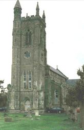
Shaftesbury is a town on the Dorset border, 28 miles north-east from Dorchester. Roman coins have been found during excavations and the town was mentioned in the Domesday Book. An abbey was established in the 6th century and it was a place of pilgrimage at one time. The town is on a hill for which there is a steep ascent. The parish of St Peter covers the main part of the town, St James covers the lower part of the town and was described as mainly small tenements in the 19th century. Holy Trinity is to the south and west. Under the Local Government Act of 1894 large parts of the three parishes became the borough of Shaftesbury. Holy Trinity church which is in Bimport Street was completely rebuilt on the old site in 1842. |
It is built in the Early English style and comprises nave, aisles, north and south galleries, choir, north and south porches and square embattled western tower, 100 feet in height, with pinnacles and containing six bells. It will seat 834 persons. The churchyard of the Holy Trinity contains three handsome avenues of lime trees. The church registers date from 1581. The population of the civil parish in 1871 was 974 and 907 in 1891. The area covers 353 acres. |
|
|
If you contact Karen please put 'OPC Shaftesbury' as the subject line |
|
| Census | The following
have been transcribed so far 1841, 1861, 1871, 1881 & 1891 |
| Parish Registers |
Baptisms
1695-1730, 1731-1770, 1771-1812, 1813-1837, 1838-1863 Marriages 1695-1837, 1837-1850 Burials 1695-1750, 1751-1812, 1813-1849, 1850-1875 |
| Postal Directories | Transcriptions of the
1830, 1842, 1851, 1865, 1895 & 1935 directories are available. |
| Land Tax & Land Owners | Owners of Land 1873 |
| Monumental Inscriptions | A list of names featured on Burial Monuments in the church ground |
| Other Records |
Commonwealth War Graves in the Borough Cemetery [Richard Smith] Commonwealth War Graves in the Churchyard [Richard Smith] |
| Photographs | Photographs
of Shaftesbury Shaftesbury photographs courtesy of Rick Frear |
| Maps | |
|
View Larger Map |
|
| Records held at the Dorset History Centre [Ref PE-SY(HT)] |
Registers Christenings 1695-1986. Marriages 1695-1977. Burials 1695-1913. Banns 1234-2345 |
| Registration District
(for the purpose of civil registration births, marriages & deaths) |
1 Jul 1837-31 Mar 1937: Shaftesbury 1 Apr 1937-31 Mar 1974: Sturminster 1 Apr 1974-17 Oct 2005: North Dorset |
Visitors to Dorset OPC
Copyright (c) 2025 Dorset OPC Project