Puncknowle
including Bexington
|
Puncknowleincluding Bexington |
|
|
|
|
| A Parochial School was built in 1851 for
130 children. There was also a Wesleyan chapel in the parish and
there used to be a coastguard station at Bexington. The soil is clay
and the chief crops are wheat, oats and barley. The parish covers an
area of 2040 acres of land and 120 acres of water and foreshore. The
population in 1891 was 427 persons. |
|
The Online Parish Clerk (OPC) for Puncknowle is Judy Hodges Transcriptions are gradually being added to the site. Other records I have available are listed. All transcriptions and indexes used to answer queries have been made by me. The list below represents the main transcriptions I have, there may well be other smaller items not listed, so it is always worth contacting me. |
|
| Census | I have transcriptions
of the following census:- 1841, 1851, 1861, 1871, 1881 & 1891 1871 Census online [John Ridout] |
| Parish Registers |
Baptisms 1633-1800, 1801-1836, 1837-1880 Marriages 1632-1836 Burials 1631-1942 |
| Postal & Street Directories | Pigot's 1865 & Kelly's 1903 |
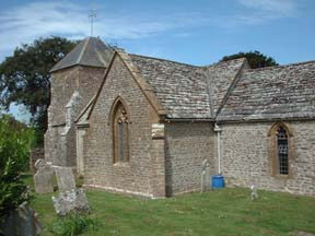
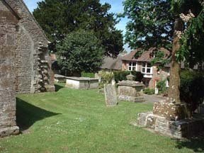
| Church | I have a history of the church St Mary's Monumental Inscriptions index [Jan Hibberd] Old Cemetery Monumental Inscriptions index [Jan Hibberd] New Cemetery Monumental Inscriptions index [Jan Hibberd] |
| Militia Records | I have some militia records available for the parish |
| Maps | The 1891 Ordnance Survey maps of
the parish can be seen at the old-maps site,
just enter 'Puncknowle' under place search. For modern location maps & aerial views visit:- |
|
View Larger Map |
|
| Records held at the Dorset History Centre [PE-PUN] |
Registers Christenings 1630-1658, 1665-1685/6, 1697/8-1981 Marriages 1632/3-1644, 1666-1692, 1700-1926 Burials 1631-1942. Banns 1754-1920 |
| Registration District (for the purpose of civil registration births, marriages, deaths & civil partnerships) |
1 Jul 1837-31 Mar 1997: Bridport 1 Apr 1997-30 Sep 2001: West Dorset 1 Oct 2001-17 Oct 2005: South & West Dorset |
|
|
|
Visitors to Dorset OPC
Copyright (c) 2025 Dorset OPC Project