Powerstock
including the Chapelry of West Milton
|
Powerstockincluding the Chapelry of West Milton |
|
|
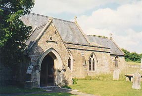
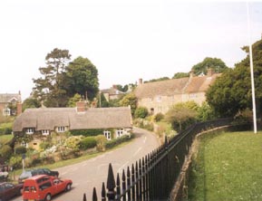
Powerstock (or Poorstock) is a village, situated in a steep valley on the edge of the Dorset Downs 5 miles north east from Bridport. Within the parish is Eggerton Hill which has the remains of two Roman camps. The church of St Mary, situated on a hill over the village, dates from Norman times and the chancel arch is an excellent example of Early Norman architecture. Outside is a very rare 13th century Dole Table, from pre-Reformation times when charitable doles of bread were distributed to the poor. Inside the south entrance is a 15th century carving of a king and crowned woman giving bread to children. The church registers date from 1568. |
|
|
|
Within the parish lie the tithings of
South Poorton, West Milton and
Nettlecombe. At West Milton is St Mary
Magdalene's, a chapel of ease to Powerstock church erected in 1873,
there was also a Wesleyan chapel in the hamlet. Nettlecombe contained a
fine old manor house called Mappercombe which is now a farm house, there
was also a Wesleyan chapel in this hamlet and the railway station used
to be here. Powerstock railway station (and the entire Bridport branch line)
closed on 5 May 1975 |
|
|
| Census |
1841 Census [John Ridout] 1851 Census [Jim Riglar] 1861 Census 1871 Census [John Ridout] 1881 Census [Jim Riglar] 1891 Census [John Ridout] 1901 Census [Jim Riglar] 1911 Census [Jim Riglar] |
| Parish Registers | Baptisms 1739, 1784, 1788-89, 1803 [Louise Anning], 1813-1836 [Jim Riglar], 1849-50, 1853-54, 1861, 1869-70, 1878-79 [Louise Anning] Marriages 1837-1920 [Louise Anning] Burials 1717-1748, 1749-1787, 1787-1812[Jim Riglar] 1813-1851, 1851-1895 [Louise Anning] West Milton Marriages 1837-1921 [Louise Anning] |
| Bishops Transcripts |
Baptisms 1731-1777, 1778-1817,
1818-1843, 1844-1880 [Sandy
Pearcey] Marriages 1568-1719, 1720-1837 [Sandy Pearcey] |
| Overseers Accounts | Extracts from
the Overseers Accounts 1756-1757
and 1757-1758 List of Overseers 1747-1774 |
| Wills | A index of Wills and Administrations for Powerstock residents proven in Dorset |
| Hearth Tax Protestation Return |
A short list of those
paying the Hearth Tax in
1663 [Tony Higgins] Those named in the Protestation Return of 1641 [Tony Higgins] |
| Photographs | Ten photographs of the church and village |
| Maps | The 1891 Ordnance Survey maps of the parish can be seen at the old-maps site, just enter 'Powerstock' under place search. |
|
View Larger Map |
|
| Records held at the Dorset History Centre [Ref PE-POW] |
Registers Christenings 1568-1970. Marriages 1568-1995. Burials 1568-1645/6, 1651-1895. |
| Registration District
(for the purpose of civil registration births, marriages & deaths) |
1 Jul 1837-31 Mar 1937: Beaminster 1 Apr 1937-31 Mar 1997: Bridport 1 Apr 1997-17 Oct 2005: West Dorset 1 Oct 2001-17 Oct 2005: South & West Dorset |
Visitors to Dorset OPC
Copyright (c) 2025 Dorset OPC Project